The Skeleton Coast
Stark and Fascinating
August, 2014
Click on any image for a larger view;
Contact garya at this domain if you would like the high quality image for printing
When we left Damaraland and crossed into
Skeleton Coast National Park,
we had to pass through a check station at Springbokwasser.
While it wasn't a pass in the geographic sense,
it felt like one.
We began dropping down noticeably onto the seemingly barren rock and sand of the Skeleton Coast.
What sparse grass there was disappeared,
and we were in a land of sand and broken rock.
 |
| Leaving Damaraland |
 |
 |
| Skeleton Coast |
The guard at the entrance station was adamant that we could not spend the night
and had to be out by 18:00.
He also was adamant that we not even stop at Torra Bay,
a seasonal coastal vacation spot down on the coast.
We had been keeping an eye on the fuel gauge.
We had tried to fuel up at Palmwag,
but it didn't have a fuel station any more;
the town didn't even seem to be there.
Maybe we didn't go far enough, as it was a little off our intended path
and we didn't want to waste fuel looking for ... fuel.
The gas gauge indicated we were still in good shape,
and the map showed fuel at Torra Bay.
When we approached the coast, the road ended in a tee.
We headed north, as we wanted to check out the environment along the
Uniab River.
The road turned to packed sand, and at one point I stopped to take a picture.
We had gone too far for the image I wanted,
and rather than get out and walk I started backing up.
I was a little cavalier in my approach to backing,
glancing in the mirrow occasionally while mainly looking out for the image I wanted.
Mistake.
Big mistake.
The right side of the vehicle went off the packed sand, we heard a "clunk", and we stopped.
I tried to ease back forward but no go.
I got out and walked around the car and it didn't look like we should be stuck;
I'm used to dealing with cars getting stuck in snow and mud,
and we shouldn't be stuck.
We were on a wide-open beach, for crying out loud!
I moved some sand around but to no avail.
Finally, I looked under the car and discovered the right front wheel was high-centered on a rock!
In this expanse of sand.
I couldn't easily move it out of the way;
we were going to have to jack the car up,
assuming the rock was un-attached and would actually move.
I started unloading the trunk but just then another car drove up
(one of those outfitted for the worst case scenario rental 4WD camping vehicles)
so we borrowed their jack.
In short order we were good to go.
Whew!
I am no longer allowed to back up;
that part of my license has been revoked by Dona.
 |
| The Rock that got us Stuck |
Then I took my picture.
It was of ... rocks.
In this expanse of sand.
 |
| Skeleton Coast |
We made it to the Uniab River,
and it's a good thing we weren't planning on going any further;
the road just past it was impassable except for 4WD vehicles.
Or at least that's what it looked like;
we didn't try it.
The Uniab River is an oasis amid a sea of dry rock and sand.
It is an incongruous looking scene --
bright green marsh grasses butting up to barren rock and sand.
There were birds wading in the small puddles,
and oryx feeding and resting in the tall grasses.
The river itself just barely existed,
as a small trickle of running water.
Whether it was flowing above ground for the whole way was debateable.
 |
| Uniab River Oryx |
 |
| Springbok |
 |
 |
| Red Knobbed Coot |
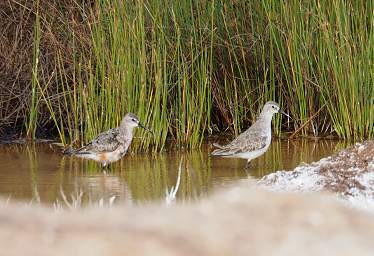 |
 |
| Curlew Sandpiper |
 |
| Curlew Sandpiper |
We parked the car and walked a short ways up the river.
It was a raw, cool place, cloudy / foggy from the ocean.
We didn't have much time, which was a big disappointment.
I wanted to spent at least a whole day exploring up the riverbed,
but it was already late afternoon and we had to be out of the park by 18:00.
 |
 |
| Looking Up the Uniab River |
Looking Down the Uniab River |
 |
| Uniab River Rocks |
 |
| Uniab River |
 |
 |
| Oryx |
 |
 |
| Blacksmith Lapwing |
As we left the river to head back, we saw movement in the mirage-prone distance
and sure-enough, it was another animal -- ostriches.
They were totally unexpected, but that just shows how little I know about both this environment and ostriches.
 |
| Ostriches adjacent to the Uniab River |
On our return drive down the coast, we stopped for a closer look at this environment's most common plant,
the Dollar Bush.
It's a succulent; its leaves are an important source of water for the inhabitants of this sparse country.
 |
 |
| Skeleton Coast Near Shore |
Dollar Bush |
Every time I looked out at the ocean,
then up and down the coast,
then eastward to the dunes and rock,
I couldn't help but think of the sense of complete dispair someone shipwrecked on this coast would feel.
At first you might hold out some hope,
but then you climb the nearest dune and all you see is more of the same.
I wonder if anyone has survived a shipwreck here in times before twentieth century communications.
The few who could were probably never shipwrecked here.
 |
 |
| Skeleton Coast |
 |
| Skeleton Coast |
 |
| Skeleton Coast |
On the way back we stopped to stare at Torra Bay, the seasonal "town" on the shore.
People must really like their ocean fishing to spend much time there.
We had hoped to purchase gas here,
but it is absolutely desserted except in December and January,
during the holiday vacation period.
Then it's booked solid by fisherpeople.
 |
 |
| Torra Bay |
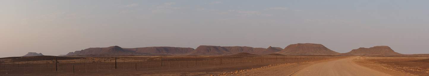
We left the coast and headed back eastward, the only vehicle for miles around.
 |
| Skeleton Coast |
As we headed inland, it was hard not to wonder about the
very tall game fence running continuously along the north side of the road.
What purpose did it serve in today's world?
The fence, officially known as the "Rooilyn Vet Fence",
but usually referred to as the
"Red Line",
was built in colonial times ostensibly to help control animal diseases.
Livestock north of the line potentially harboured diseases which were not present south of the line.
The fence has huge economic consequences,
as farmers north of the line are not allowed to sell their meat south of the line,
or export it.
As a practical matter, it gives market protection to more wealthy individuals,
mostly white, on large commercial farms south of the line
and relegates those north of the line to subsistence farming.
 |
| Skeleton Coast |
In this apparently barren landscape,
only specially adapted plants do well and survive.
We found some Welwitchia plants growing alongside the road.
They have only two leaves, and can live to be over one thousand years old.
That's one hardy plant.
In the picture below, it looks like there are more than two leaves.
What happens is that the individual leaves fray,
so the split ends look like multiple leaves.
 |
| Welwitchia |
 |
| Skeleton Coast |
 |
 |
| Skeleton Coast |
One of the consequences of the vet / red line fence
is that wildlife cannot disperse across the line.
This lone oryx clearly wanted to go north, but couldn't.
While the government has claimed their intent to remove the fence,
not much has happened in reality;
it's a sad and unfortunate state of affairs.
 |
| Oryx |
The Namibian coastal areas seem to have a near constant wind;
and all of the country has near constant sunshine.
If ever there was a country ideally suited to be totally energy independent from clean renewable sources,
Namibia is surely one.
Solar could be sited almost anywhere,
so avoiding valuable natural areas would not be particularly difficult.
Wind would have to be carefully sited,
but there are already developed areas where it would easily fit in without substantial environmental consequences.
Every country should be so lucky.
It was nearing sunset as we headed back east out of the Skeleton Coast area;
on the way in I had made a mental note that this could be outstanding when we returned --
the area is full of mesas reminescent of Arizona and Utah,
and it faces the setting western sun.
I was hoping for a spectacular sunset,
but it was pretty uninspiring due to haze or fog off the ocean.
It was dark by the time we were a few km out of the park,
still low on fuel and unsure of our destination for the night.
 |
| Skeleton Coast Sunset |
After staring some more at the map and checking our guide book,
our plan was to camp somewhere near
Burnt Mountain and Organ Pipes monuments,
and fuel up in Twyfelfontein.